CapitalThe Valley
LanguagesEnglish
CurrencyEast Caribbean dollars
Governmentparliamentary democracy (House of Assembly); self-governing overseas territory of the UK
Bamwor Indexes
Anguilla — Q1 2026
IBEUBamwor Urban Scale Index
10.48%
Rank #150 of 237
View full ranking →
IBCPBamwor Population Concentration Index
24.73%
Rank #136 of 237
View full ranking →
IBDABamwor Settlement Density Index
494.51per 1K km²
Rank #34 of 241
View full ranking →
IBCXBamwor Country Complexity Index
33.93/100
Rank #205 of 234
View full ranking →
IBEEBamwor Economic Stability Index
91.88/100
Rank #34 of 220
View full ranking →
IBSABamwor Healthcare Index
81.37/100
Rank #24 of 218
View full ranking →
Anguilla Intelligence Report
Download PDF with 20+ statistics, rankings & proprietary indices
Introduction
Background
In 1650, English colonizers from Saint Kitts established a settlement in Anguilla. The governance of the island was under British control until the early 19th century, when, contrary to the desires of the local population, Anguilla was merged into a single British dependency that included Saint Kitts and Nevis. Numerous efforts to gain independence were unsuccessful. It was not until 1971, following a rebellion, that Anguilla was permitted to break away; this status was officially acknowledged in 1980, marking Anguilla's emergence as an independent British dependency. In 2017, the island suffered significant destruction due to Hurricane Irma, which severely impacted communication systems and both residential and commercial infrastructure.
Geography
Area
land
91 sq km
water
0 sq km
total
91 sq km
Climate
tropical; influenced by northeast trade winds
Terrain
a low-lying and flat island composed of coral and limestone
Land use
other
38.9% (2022 est.)
forest
61.1% (2022 est.)
agricultural land
0% (2022 est.)
agricultural land: arable land
arable land: 0% (2018 est.)
agricultural land: permanent crops
permanent crops: 0% (2018 est.)
agricultural land: permanent pasture
permanent pasture: 0% (2018 est.)
Location
located in the Caribbean, among the islands positioned between the Caribbean Sea and the North Atlantic Ocean, to the east of Puerto Rico
Coastline
61 km
Elevation
lowest point
Caribbean Sea 0 m
highest point
Crocus Hill 73 m
Irrigated land
0 sq km (2020)
Map references
Central America and the Caribbean
Land boundaries
total
0 km
Maritime claims
territorial sea
12 nm
exclusive fishing zone
200 nm
exclusive economic zone
200 nm
Natural hazards
prone to frequent hurricanes and other tropical storms occurring from July to October
Geography - note
the northernmost island of the Leeward Islands in the Lesser Antilles
Natural resources
salt, fish, and lobster
Area - comparative
approximately half the size of Washington, D.C.
Geographic coordinates
18 15 N, 63 10 W
Population distribution
the majority of the populace is centered in The Valley at the island's core; settlement patterns are relatively uniform in the southwest, whereas they are quite sparse in the northeast
People & Society
Languages
English (official)
Religions
Protestant 73.2% (includes Anglican 22.7%, Methodist 19.4%, Pentecostal 10.5%, Seventh Day Adventist 8.3%, Baptist 7.1%, Church of God 4.9%, Presbyterian 0.2%, Brethren 0.1%), Roman Catholic 6.8%, Jehovah's Witness 1.1%, other Christian 10.9%, other 3.2%, unspecified 0.3%, none 4.5% (2011 est.)
Sex ratio
at birth
1.03 male(s)/female
0-14 years
1.03 male(s)/female
15-64 years
0.83 male(s)/female
total population
0.88 male(s)/female (2024 est.)
65 years and over
0.93 male(s)/female
Birth rate
11.69 births/1,000 population (2025 est.)
Death rate
4.76 deaths/1,000 population (2025 est.)
Median age
male
34.8 years
total
37.5 years (2025 est.)
female
39 years
Population
male
9,107
total
19,416 (2024 est.)
female
10,309
Nationality
noun
Anguillan(s)
adjective
Anguillan
Urbanization
urban population
100% of total population (2023)
rate of urbanization
0.47% annual rate of change (2020-25 est.)
Age structure
0-14 years
20.8% (male 2,056/female 1,992)
15-64 years
67.5% (male 5,958/female 7,147)
65 years and over
11.7% (2024 est.) (male 1,093/female 1,170)
Ethnic groups
African/Black 85.3%, Hispanic 4.9%, mixed 3.8%, White 3.2%, East Indian/Indian 1%, other 1.6%, unspecified 0.3% (2011 est.)
Dependency ratios
total dependency ratio
48.2 (2024 est.)
youth dependency ratio
30.9 (2024 est.)
potential support ratio
5.8 (2024 est.)
elderly dependency ratio
17.3 (2024 est.)
Physician density
1.51 physicians/1,000 population (2018)
Net migration rate
10.13 migrant(s)/1,000 population (2025 est.)
Total fertility rate
1.72 children born/woman (2025 est.)
Drinking water source
improved: total
total: 97.5% of population
Education expenditure
Education expenditure (% GDP)
2.5% of GDP (2022 est.)
Education expenditure (% national budget)
10.3% national budget (2024 est.)
Infant mortality rate
male
3.9 deaths/1,000 live births
total
2.9 deaths/1,000 live births (2025 est.)
female
2.1 deaths/1,000 live births
Population growth rate
1.71% (2025 est.)
Gross reproduction rate
0.85 (2025 est.)
Population distribution
the majority of the populace is centered in The Valley located in the island's heart; the southwest exhibits relatively even settlement, whereas the northeast remains quite sparsely populated.
Life expectancy at birth
male
80 years
female
85.3 years
total population
82.6 years (2024 est.)
Major urban areas - population
1,000 THE VALLEY (capital) (2018)
Environment
Climate
tropical; influenced by northeastern trade winds
Land use
other
38.9% (2022 est.)
forest
61.1% (2022 est.)
agricultural land
0% (2022 est.)
agricultural land: arable land
arable land: 0% (2018 est.)
agricultural land: permanent crops
permanent crops: 0% (2018 est.)
agricultural land: permanent pasture
permanent pasture: 0% (2018 est.)
Urbanization
urban population
100% of total population (2023)
rate of urbanization
0.47% annual rate of change (2020-25 est.)
Environmental issues
insufficient drinking water
Government
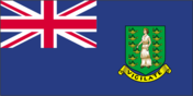
Flag
description: the flag is blue, featuring the UK flag in the upper-left corner and the Anguillan coat of arms prominently displayed on the outer half; the coat of arms depicts three orange dolphins in an interlocking circular formation against a white backdrop, with a turquoise-blue field beneath
meaning: the white in the coat of arms symbolizes peace; the blue background represents the sea, faith, youth, and hope; the three dolphins signify endurance, unity, and strength.
Capital
name
The Valley
etymology
name may derive from the capital's location among several hills
time difference
UTC-4 (1 hour ahead of Washington, DC, during Standard Time)
geographic coordinates
18 13 N, 63 03 W
Suffrage
18 years of age; universal
Citizenship
see United Kingdom
Constitution
history
several previous; latest 1 April 1982
Country name
etymology
in 1493, Christopher COLUMBUS named the island Anguilla, which translates to "eel" in Spanish, due to the island's elongated shape.
conventional long form
none
conventional short form
Anguilla
Independence
none (overseas territory of the UK)
Legal system
common law derived from the English legal system
Government type
parliamentary democracy (House of Assembly); self-governing overseas territory of the UK
Judicial branch
highest court(s)
the Eastern Caribbean Supreme Court (ECSC) serves as the highest court of the Organization of Eastern Caribbean States; it is located in St. Lucia and comprises the Court of Appeal, led by the chief justice and four judges, and the High Court with 18 judges; the Court of Appeal visits member nations periodically to adjudicate appeals from the High Court and lower courts.
subordinate courts
Magistrate's Court; Juvenile Court
judge selection and term of office
the chief justice of the Eastern Caribbean Supreme Court is appointed by the British monarch; additional justices and judges are appointed by the Judicial and Legal Services Commission; justices of the Court of Appeal serve for life but must retire at age 65; High Court judges also serve for life with a mandatory retirement age of 62.
Executive branch
cabinet
Executive Council appointed by the governor from among elected members of the House of Assembly
chief of state
King CHARLES III (since 8 September 2022); represented by Governor Julia CROUCH (since 11 September 2023)
head of government
Premier Cora RICHARDSON-HODGE (since 27 February 2025)
election/appointment process
the monarchy is hereditary; the governor is appointed by the monarch; after legislative elections, the governor typically appoints the leader of the majority party or coalition as premier.
National holiday
Anguilla Day, 30 May (1967)
Dependency status
overseas territory of the UK
Political parties
Anguilla Progressive Movement or APM; (previously Anguilla United Movement or AUM)
Anguilla United Front or AUF
Legislative branch
term in office
5 years
number of seats
11 (7 directly elected, 2 appointed, 2 ex-officio members)
electoral system
plurality/majority
legislature name
House of Assembly
scope of elections
full renewal
legislative structure
unicameral
most recent election date
6/29/2020
percentage of women in chamber
27.3%
parties elected and seats per party
APM (7); AUF (4)
National anthem(s)
title
"God Save the King"
history
official anthem, as an overseas UK territory
lyrics/music
unknown
National symbol(s)
dolphin
National coat of arms
the Anguillan coat of arms showcases three interlocking dolphins leaping from seawater; they symbolize endurance, unity, and strength, while their circular movement represents continuity; the white background denotes peace and tranquility, and the turquoise-blue base symbolizes the sea, as well as faith, youth, and hope.
Diplomatic representation in the US
none (overseas territory of the UK)
Diplomatic representation from the US
embassy
none (overseas territory of the UK); alternative contact is the US Embassy in Barbados [1] (246) 227-4000
International organization participation
Caricom (associate), CDB, Interpol (subbureau), OECS, UNESCO (associate), UPU
Economy
Budget
revenues
$81.925 million (2017 est.)
expenditures
$72.352 million (2017 est.)
Exports
Exports 2016
$3.9 million (2016 est.)
Exports 2017
$7.9 million (2017 est.)
Industries
tourism, boat manufacturing, offshore financial services
Public debt
Public debt 2014
20.8% of GDP (2014 est.)
Exchange rates
Currency
East Caribbean dollars (XCD) per US dollar -
Exchange rates 2020
2.7 (2020 est.)
Exchange rates 2021
2.7 (2021 est.)
Exchange rates 2022
2.7 (2022 est.)
Exchange rates 2023
2.7 (2023 est.)
Exchange rates 2024
2.7 (2024 est.)
Economic overview
A small economy reliant on tourism, characterized by a territorial-island setting; has a very high level of public debt; economic activities were severely impacted by COVID-19; a partial recovery is in progress through tourism, which is benefiting from a significant number of timeshare properties; contemplating the reopening of an oil refinery.
Exports - partners
Chile 60%, Netherlands 8%, Brazil 5%, Hungary 4%, USA 4% (2023)
Imports - partners
Chile 50%, USA 27%, Botswana 15%, Japan 1%, Dominican Republic 1% (2023)
Real GDP per capita
Real GDP per capita 2022
$27,400 (2022 est.)
Real GDP per capita 2023
$28,900 (2023 est.)
Real GDP per capita 2024
$31,000 (2024 est.)
Agricultural products
Small amounts of tobacco, vegetables; cattle farming.
Exports - commodities
packaged medicine, garments, vehicle parts/accessories, vaccines, cars (2023)
Imports - commodities
poultry, copper ore, natural gas, refined petroleum, fish (2023)
GDP (official exchange rate)
$452.73 million (2024 est.)
Inflation rate (consumer prices)
Inflation rate (consumer prices) 2020
-0.5% (2020 est.)
Inflation rate (consumer prices) 2021
1.8% (2021 est.)
Inflation rate (consumer prices) 2022
3% (2022 est.)
Real GDP (purchasing power parity)
Real GDP (purchasing power parity) 2022
$336.924 million (2022 est.)
Real GDP (purchasing power parity) 2023
$345.238 million (2023 est.)
Real GDP (purchasing power parity) 2024
$362.499 million (2024 est.)
Energy
Electricity access
electrification - total population
100% (2020)
Communications
Internet users
percent of population
81.6% (2021 est.)
Broadcast media
One private television station exists; subscription services for multi-channel cable television are offered; there are approximately 10 radio stations, including one that is owned by the government (2024)
Internet country code
.ai
Telephones - fixed lines
total subscriptions
6,000 (2021 est.)
subscriptions per 100 inhabitants
38 (2021 est.)
Telephones - mobile cellular
total subscriptions
25,870 (2022 est.)
subscriptions per 100 inhabitants
163 (2022 est.)
Broadband - fixed subscriptions
total
5,000 (2018 est.)
subscriptions per 100 inhabitants
35 (2018 est.)
Transportation
Airports
1 (2025)
Merchant marine
total
2 (2023)
by type
other 2
Civil aircraft registration country code prefix
VP-A
Military & Security
Military - note
The obligation for defense lies with the United Kingdom.